


Outdoor Navigation app for iPhone and iPad
Developer: GPS Tuner Systems Kft.
First release : 24 Nov 2010
App size: 21.79 Mb
A NEW LEVEL OF OFF-ROAD NAVIGATION EXPERIENCE.
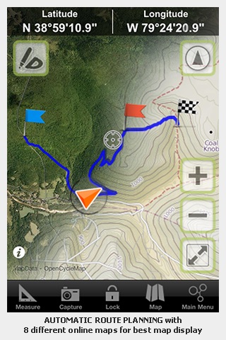
8 ONLINE MAPS | 40 TRIP COMPUTER TOOLS | VISUAL GRAPHS | SHARING WAYPOINTS | EMERGENCY MESSAGES
• Flexibility - ease of use, selectable maps, stored map content
• All-in-One - a complete set of handy tools in one solution at your fingertips
• High Performance - fast, accurate and reliable
GPS Tuner features GROUNDBREAKING off-road navigation software specifically designed for the iPhone. As opposed to traditional car navigation that plans your route based on a road network, GPS Tuner gives you the ability to navigate where the roads end.
• Leverage online route planning for pedestrians or vehicles when an in an urban environment
• Find your bearings and GPS position instantly and display it on a map
• Select from 8 different types of online maps from multiple providers.
• Save and export an UNLIMITED NUMBER of routes with a tap of your iPhone display
• iPhone’s digital compass functionality is integrated to display real heading and target direction for more accurate positioning and heading
• Bubble level to assist in measuring slopes
• A set of 3 different speedometers with speed limit warnings
• 40 selectable trip computer tools with multiple layout options
• Track recording and analyzing
• Trip computer charts to visualize performance data
• Multiple trip stats can be displayed in one chart for thorough analysis
• Emergency email messages allow you to stay connected! You’ll never be out of sight within cellular network coverage. You can request assistance and share your position with your friends, coworkers or emergency response services.
NO PAPER MAPS AND NO HASSLE WITH FINDING YOUR BEARINGS IN AN OUTDOOR ENVIRONMENT.
STORED MAPS - download online maps on the fly!
• Maps in GPS Tuner can be stored on your iPhone’s internal storage for fast, reliable offline access and fast map rendering!
• GPS Tuner displays your geographical location and tracks routes and waypoints in selected maps or satellite imagery.
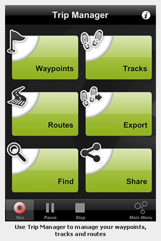
Share your Waypoints
• Share your location, details and photos directly via Facebook and send your GPS postion to Twitter. Email and share .kml,.kmz,.gpx files with location and track informations that can be viewed with Google Earth
• Add photos to waypoints and display them as rich POI content
Tested and compatible with: iPhone 3GS, iPhone 4
Continued use of GPS running in the background can dramatically decrease battery life.